ARTICLES

One of the Richest Beaches Ever Mined
(Reprinted from the California Mining Journal)
https://www.icmj.com/magazine/article/one-of-the-richest-beaches-ever-mined-3233/
April 2015 by Jim Halloran
Everyone has heard of the golden beach at Nome, but Nome did not have the richest beach. The truth is the richest beach in Alaska and perhaps the entire world was at Bluff, Alaska, or so say the reports. Bluff’s beach, 50 miles east of Nome, was “…one of the richest beaches ever mined” (Collier and others, 1908). It may not have produced as much total gold as Nome’s beach because the beach at Bluff is much smaller, but its gold per square foot was richer than Nome. The onshore placers at Bluff have been mostly exploited today, but the offshore submerged beaches and former channels of Daniels Creek remain mostly unmined.
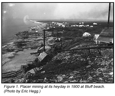
Bluff’s beach gold was discovered in September of 1899 at the mouth of Daniels Creek by William Hunter and Frank Walker, and claims were staked during the following winter. The discovery of gold at Bluff did not reach the outside world (Nome) until March of 1900. By the late summer of 1900, the “easy” gold was practically mined up. In the span of that one year, 29,000 ounces had been scooped up from about 1,000 feet of the shoreline (figure 1). Beach mining extended for about three miles to the west of Daniels Creek. The really rich golden placers were developed by the surf reconcentrating the stream placer of Daniels Creek.
The placers on Daniels Creek were also intensely mined, as shown in figure 2. The nearby lode deposits were located, staked and being mined by 1900. A ditch system was constructed to supply water for hydraulic mining that same year. The neighboring creeks, Eldorado and Swede, were mined by the time WWII shut down gold mining. The miners at Daniels Creek discovered the gold they produced came from a series of connected sink holes in the marble bedrock. Some of the sink holes near Norton Sound were deep enough to be below sea level. This indicated to them that sea level was lower in the geologic past and the rich Daniels Creek paystreak extended offshore for some distance.
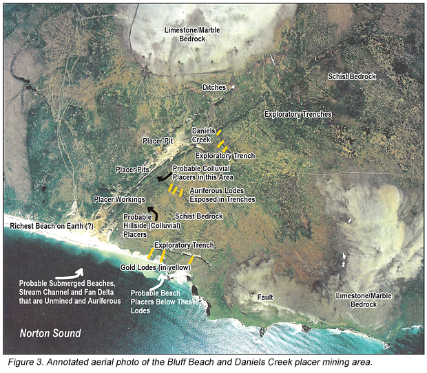
Bedrock in this district is quartz-mica schist, limestone or marble (sometimes called meta-limestone) and an altered intrusive rock. Lode gold along with pyrite, arsenopyrite and chalcopyrite were found with quartz and calcite veins piercing the schist. Other heavy minerals include magnetite, ilmenite, and cinnabar. Three lodes were exposed in the sea cliffs (figure 3 on page 22) where they were striking in a northerly direction as far as 4,000 feet. The lodes in the cliffs were 60 to 165 feet wide and widen to the north to 100 to 200 feet (Mulligan, 1971). The grade of the quartz veins was 0.029 to 0.058, with the best at 0.42 ounces per ton. The lodes were explored and exploited with pits, trenches, shallow shafts and adits in the sea cliff.
Near the mouth of Daniels Creek there were at least two beaches with one being about ten feet above the present beach. The richest portion of the beach was from 500 feet west to 50 feet east of the mouth of Daniels Creek where a foot of clean sand on top of three to four feet of gravel rests on a firm clay false bedrock. A third beach is more inferred than proven to be about 50 feet above the present beach on a bluff. At this elevation a small, wave cut terrace has been found, but it does not contain much gold.
The total gold production from this area exceeded $1 million (48,375 troy ounces) from Daniels Creek and Bluff Beach by 1904 (Collier and others, 1908). Mulligan (1971) reported the total gold production from the placers was 89,140 fine ounces, while lode production was negligible.
The beach gold was coarser than the gold at Nome beach, no doubt due to much less travel distance from the lodes to the beach. The fineness of the gold is 870. At $20.67 gold, it averaged a dollar to the pan. Brooks (1901) wrote, “This is far richer than the best part of the Nome beach sands, and, in fact, is the richest marine placer ever found.” It must have been happy times at Bluff in those days!
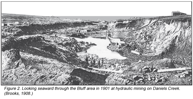
Daniels Creek is a one-mile-long drainage that flows south to its mouth on Norton Sound at Bluff beach. Gold miners on Daniels Creek plucked gold nuggets from crevices and potholes in the marble floor that were deep enough to require the hoisting of buckets of auriferous gravels. The pay channel is very irregular as small cavern features such as solution channels, potholes and tunnels are well developed. Since these features developed below the present sea level, they must have formed when the sea level was lower. It was apparent to the miners that the pay channel extended offshore. In fact, the paystreak of Daniels Creek went below sea level for several hundred feet upstream from its mouth. Some of the excavations were 50 to 60 feet below sea level.
In the 1930s, a modified high-line dragline was used to mine the nearby seafloor (Mulligan, 1971). The offshore pay zone was defined by a self-propelled 6-inch churn drill that operated on sea ice during the winters. The offshore dragline mining of the 1930s was inefficient at exploiting the deeply entrenched and winding channel paystreak and may have mined sea bottom sands by mistake at times. Mining offshore was done in the winter through the ice, but it was made challenging and hazardous due to movement of the ice. The gravels mined in the winter were stockpiled on shore for sluicing during the summer. Subsequent attempts during the 1970s at offshore mining using suction technology were unsuccessful.
The gold lodes are associated with the contact between the schist and the marble. An intensely fractured zone in the schist averages 0.015 to 0.017 ounces per ton gold and 0.03 to 0.05 ounces per ton silver for outcrop widths of 200 to almost 500 feet (Mulligan, 1971). The gold lode workings in the Daniels Creek area consist of a caved-in adit in Bluff cliff and more than 50 pits, trenches and timbered shafts. The auriferous veins are composed of quartz and calcite. The dumps are not large enough for extensive stoping; however, it is likely that some of the waste rock was dumped into the sea from adits in the cliff. One adit was reported to be 300 feet in length with winzes and crosscuts.
The best gold concentrations were residual placers on the surface of the clayey decomposed schist. Like so many placer districts around the world, the lodes were too small or poor to develop hardrock operations. There is little gold in Daniels Creek upstream of the lodes in the schist.
In 1983, Aurick Offshore Mining Co. hired Phoenix Marine Engineering Inc. to dredge near the mouth of Daniels Creek. They only applied to mine 100 acres in waters from 10 to 30 feet deep during ice-free times of the year. The plan was to mine 1,000,000 cubic yards a year for ten years. Unfortunately they were met with howls of protests from the usual environmental groups that believed mining no more than 100 acres out of hundreds of thousands of offshore acres would adversely affect the whales that occasionally swim by Bluff. There are no year-round residents of Bluff anymore.
In 1986, BHP conducted geological, geochemical, geophysical and core drilling programs looking for lode gold. BHP discovered significant drill intersections as high as 5.48 grams per ton (g/t) gold over 36 feet. In their report, they noted a resource of 300,000 ounces in 3,000,000 tons of 3.43 g/t ore near Daniels Creek. In recent years, Millrock Resources picked up where BHP left off with more geologic mapping and soil sampling of new mineralized zones in bedrock sources of the gold at Bluff. In 2010, Millrock had a drill intersection of 103 feet of 3.8 g/t and another of 9.0 g/t over 40 feet. Due to the structural complexity of the geology, they flew detailed airborne magnetic and radiometric surveys. Millrock entered into an exploration agreement with Ryan Gold and Bering Straits Native Corporation at Bluff. In 2013, Millrock dropped the Bluff lode project.
The seafloor offshore of Bluff has a reputation of having lots of old mining debris, which creates a hazard to new mining. A new operation would be well-advised to clean up enough of the cables and scrap metal parts to mine safely. Another risk is the chop of the waves, which is reported to be really tough on boats. The weather and surf conditions can get tough and there is no harbor for shelter nearby.
A note about prospecting beaches for placers: there are some common factors to look for. One of the factors is exemplified at Bluff; in fact it is the word “bluff,” or sea bluffs. Many beach placers are associated with seashore bluffs. The bluffs are the result of a shoreline that is rapidly eroding. The surf, usually during storms, undermines the toe of the bluff slope, causing it to slough down onto the beach where the heavy minerals are naturally sluiced into beach placers. Not all beach placers are associated with bluffs, but the majority of them are. Conversely, not all golden beaches are associated with sea cliffs. The present beach at Nome is an exception to the previous sentences, but the Nome district has so many lodes over a very large area. The Third Beach at Nome follows the rule with a bluff above it. Needless to say, not all beaches with bluffs have gold placers, but other heavy minerals are likely to be in placer concentrations on those beaches, too. Gold Bluffs Beach, Oregon and Cook Inlet beaches in south-central Alaska are other examples and there are many more examples too numerous to cite.
It is highly likely that additional gold can be found in the colluvium between the lodes and Daniels Creek, as shown in figure 3. The natural appearing vegetation pattern indicates the area has not been mined; however, it is possible the hillside has been mined since the aerial photo was taken in 1998.
_______________
Sources
- Brooks, A.H., 1901, “A Reconnaissance of the Cape Nome and Adjacent Gold Fields of Seward Peninsula, Alaska, 1901;” U.S. Geological Survey, Special Publication.
- Collier and others, 1908, “The Gold Placers of Parts of Seward Peninsula, Alaska;” U.S. Geological Survey, B 328.
- Mulligan, J.J., 1971, “Sampling Gold Lode Deposits, Bluff, Seward Peninsula, Alaska;” U.S. Bureau of Mines, RI 7555.
© ICMJ’s Prospecting and Mining Journal, CMJ Inc.
